Gordes
Trails of the Maquis de Gordes through La Sénancole
L17
Route
Loop
Difficulty
Intermediate
Duration
8.75d
Distance
10km
Positive elevation gain
389 meters
Negative elevation gain
391 meters
Altitude
Min. 215 meters
Max. 466 meters
- circuit
- variante
- liaison
Departure / Arrival
Gordes / Gordes
Parking
Pay car park on route de Murs (D2).
profil altimétrique
Tourist service in Gordes :
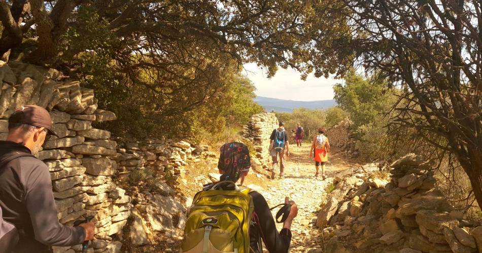
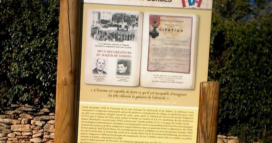
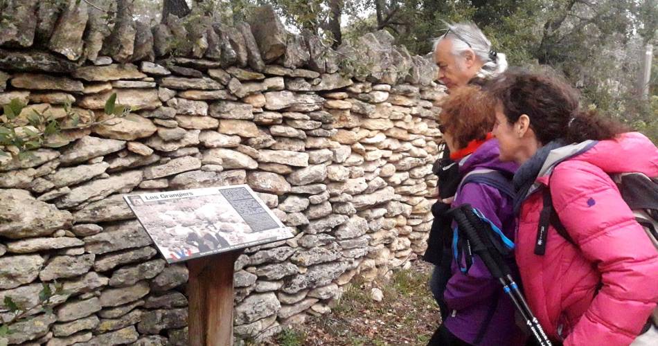
Hiking and history, following the footsteps of the members of the Resistance from Gordes (1942 - 1944)
At the Place du Château (roundabout), go along the north wall of the castle, continue on the left when reaching the Y junction, pass in front of the post office, then continue straight on the Saint-Pons street until the entrance of the cemetery (GR®).). Retrace your steps, pass under the car park and come out on "Route Neuve" (D102). Go up the Baptistin-Picca street on the right.
1 - Near the castle (tourist office), rush into the Rue de l'Eglise. Pass Saint-Firmin's church gate, turn right 20m after the Porte-de-Savoie street and go down the Jean-Deyrolle street to the left (GR®).). Pass the hairpin turn and go up the Bel-Air path. At the top, continue straight, cross the Cavaillon road (D15) and weave in between two walls. Slope down gently and keep going straight.
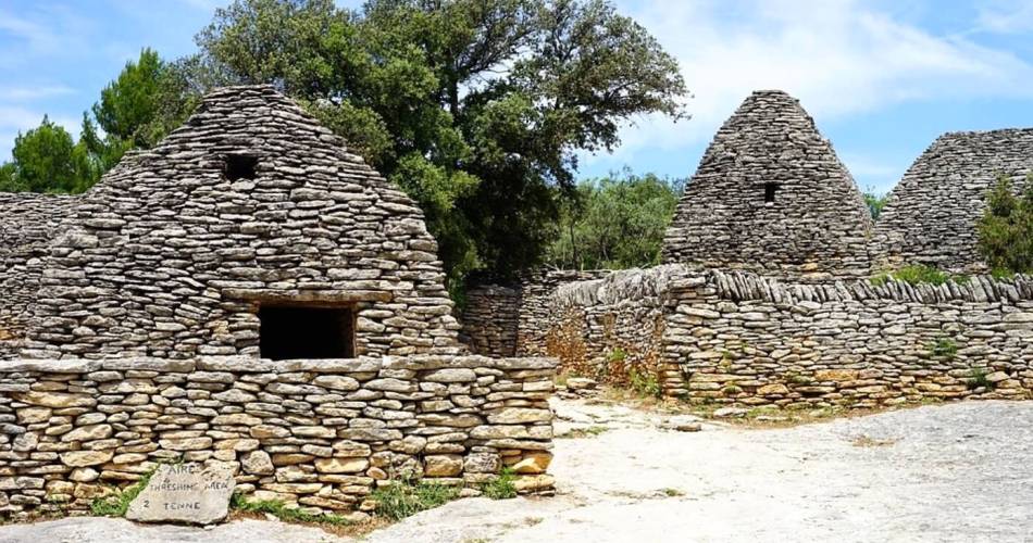
2 Leave on the right the path leading to the Village des Bories and just after the turn, take a right. Go down to the end of tar and continue straight on the cobblestone path (GR®).). At the bottom of the valley of Sénancole, turn left and then take a quick right. Leave behind the flat path on the left and climb the gravel path across. Pass a house and continue on the track to the left.
3 - At the top, turn left (RP). After the car park of the Village des Bories, go onto a trail along an olive grove on the left. Pass along a large stone wall and continue on the ridge to the right. After two narrow hairpin turns, continue the descent to the bottom of the valley and continue upstream (RP).
4 - At the crossroads "la Senancole", cross the ravine to the left and go up the trail of Grande Combe to the right. Leave a trail on the left (RP) and advance 130m further.
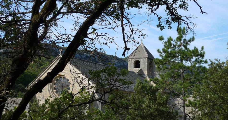
5 - Turn right, leave the valley and climb a rocky path. Once on the plateau, reach the old farm of Débroussède. Continue to the right on a poorly marked trail for about 80m and take a quick right then a left in the valley of La Sénancole. Cross the ford and reach the Senanque Abbey.
6 - Climb the path on the right going above the car park. Turn right and go up the road (GR®).). Go down the road (D177) for 100m and go onto the trail on the right (GR®).). Keep descending straight. Reach a small road. Follow it to the left and reach the Sénanque road (D177).
7 - Take the road (D177) on the right 220m further, then at a lamppost under an oak, turn left and get onto the Gordes road (D15). Turn left, pass the big curve and return to the castle (GR®).).
1 - Near the castle (tourist office), rush into the Rue de l'Eglise. Pass Saint-Firmin's church gate, turn right 20m after the Porte-de-Savoie street and go down the Jean-Deyrolle street to the left (GR®).). Pass the hairpin turn and go up the Bel-Air path. At the top, continue straight, cross the Cavaillon road (D15) and weave in between two walls. Slope down gently and keep going straight.
2 Leave on the right the path leading to the Village des Bories and just after the turn, take a right. Go down to the end of tar and continue straight on the cobblestone path (GR®).). At the bottom of the valley of Sénancole, turn left and then take a quick right. Leave behind the flat path on the left and climb the gravel path across. Pass a house and continue on the track to the left.
3 - At the top, turn left (RP). After the car park of the Village des Bories, go onto a trail along an olive grove on the left. Pass along a large stone wall and continue on the ridge to the right. After two narrow hairpin turns, continue the descent to the bottom of the valley and continue upstream (RP).
4 - At the crossroads "la Senancole", cross the ravine to the left and go up the trail of Grande Combe to the right. Leave a trail on the left (RP) and advance 130m further.
5 - Turn right, leave the valley and climb a rocky path. Once on the plateau, reach the old farm of Débroussède. Continue to the right on a poorly marked trail for about 80m and take a quick right then a left in the valley of La Sénancole. Cross the ford and reach the Senanque Abbey.
6 - Climb the path on the right going above the car park. Turn right and go up the road (GR®).). Go down the road (D177) for 100m and go onto the trail on the right (GR®).). Keep descending straight. Reach a small road. Follow it to the left and reach the Sénanque road (D177).
7 - Take the road (D177) on the right 220m further, then at a lamppost under an oak, turn left and get onto the Gordes road (D15). Turn left, pass the big curve and return to the castle (GR®).).
Go to the route
public transportation
recommended parking
Pay car park on route de Murs (D2).
road access
18 km north-east of Cavaillon on the D15.From Avignon, head towards Apt on the D900.
To note
- Between points 2 and 3, then 4 and 6: watch your ankles on the rocky and slippery sections.
- Point 7: take care when approaching Gordes.
- Be careful on the way: if the paths you take are marked GR-GRP or PR, the combination of the route is reinforced at the main crossroads by arrows with a brown Cross of Lorraine (produced by the Association des Cadres de la Résistance).
- Hunting is open from September to February. Remember to find out about the Battues before you leave.
 If you want to report a problem on your hike (marking, maintenance, danger...), let us know on Suricate: sentinels.sportsdenature.fr
Access to the massifs
Respect the regulations preserving protected natural areas – find out about restrictions to accessing the massifs during fire risk periods, from 15 June to 15 September.
Before heading out, check the website
Respect the regulations preserving protected natural areas – find out about restrictions to accessing the massifs during fire risk periods, from 15 June to 15 September.
Before heading out, check the website
In brief
- A trail commemorating the Resistance of the maquisards of Gordes during the Second World War, dotted with information panels recounting the lives of those who fought in the Resistance in the Luberon.
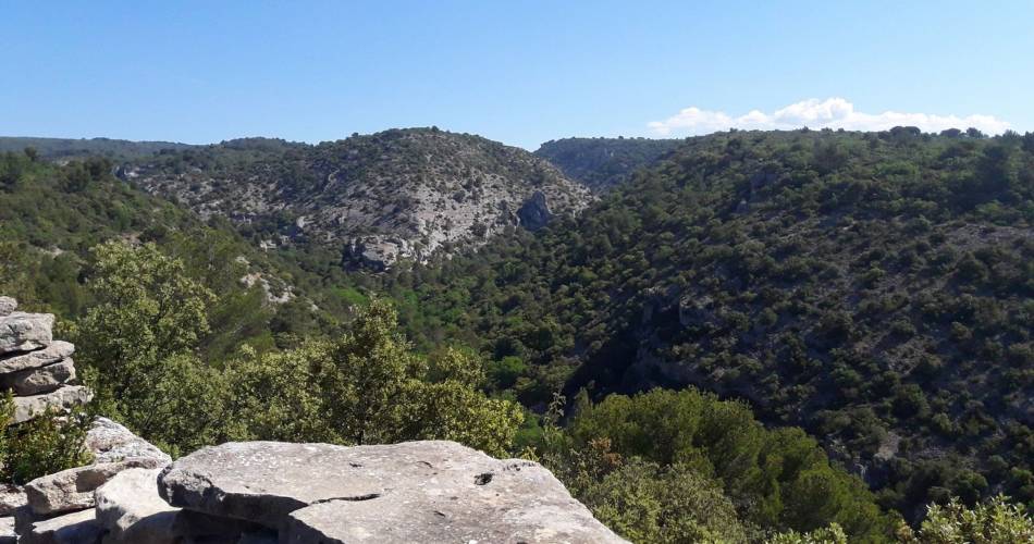
- A trail up the wild Sénancole valley, punctuated by the villages of the Bories, small dry-stone buildings typical of the Luberon, and the world-famous Sénanque Abbey.
Downloads